

1 Like
:quality(70)/cloudfront-us-east-1.images.arcpublishing.com/tronc/YUHW67RY7VFC3DBC5TXVI7DFOM.jpg)
The tropical outlook as of 8 a.m. Friday, June 24, 2022 shows a tropical wave with a 60% chance of forming into the next tropical system. (The National Hurricane Center)
The tropical wave off the African coast is moving west with improved odds of development, according to the National Hurricane Center.
The wave, which emerged Thursday morning, now has a 60% chance of becoming the next tropical depression or storm in the next five days and a 20% chance of developing in the next two days, the NHC said in its 8 a.m. update.
Thus far, the wave is producing disorganized showers and thunderstorms. Atlantic conditions have become ripe for development, which could occur early next week as the wave continues to move west between 15 and 20 mph.
If the system develops into a tropical storm, it will be the second named storm of the year, receiving the name Bonnie.
1 Like
:quality(70)/cloudfront-us-east-1.images.arcpublishing.com/tronc/FCP5J4HS5VD6NDVEF3S7UXF6LM.png)
The tropical outlook as of 8 a.m. Saturday July 25, 2022 shows two systems with potential for development. (National Hurricane Center)
The National Hurricane Center has its eye on two systems with the potential to form into the season’s next tropical depression or storm.
New on Saturday is an area of low pressure the could form early next week in the northern Gulf of Mexico. In the NHC’s 8 a.m. tropical outlook, forecasters said any development would be slow as it drifts to the west over the northwestern Gulf, with only a 20% chance of development in the next five days.
Meanwhile in the eastern Atlantic, a tropical wave that forecasters began tracking this week continues to hold medium chances for development as it marches toward the southeastern Caribbean Sea.
6/24: A thin layer of #SaharaDust over the W Atlantic will be followed by a train of tropical waves. The tropical wave near 30W has a low chance of development. Regardless of development, the tropical waves will bring gusty winds and rough seas to the #WindwardIslands by Tue. pic.twitter.com/dNqhgWQsdr
— NHC_TAFB (@NHC_TAFB) June 24, 2022
“Cloudiness and showers have become a little more concentrated near a tropical wave located over the central tropical Atlantic Ocean,” said Senior Hurricane Specialist Robbie Berg. “Environmental conditions appear conducive for development of this system over the next few days, and a tropical depression could form during the early to middle part of next week.”
This system is moving from 15 to 20 mph over the Atlantic and expected to approach the Windward Islands on Tuesday.
Forecasters give the system a 30% chance to develop in the next two days, and 60% over the next five.
Officials at the National Hurricane Center’s Tropical Analysis and Forecast Branch believe this tropical wave, which is on the trail of a thin layer of Saharan dust heading west, could be followed by more potential systems. It’s already tracking more tropical waves in the eastern Atlantic off the coast of Africa, but not yet generating forecasts.
1 Like

We volunteer as tribute to take a chunk of tame tropical weather! We desperately need the rain (and to break up this ongoing stretch of Random Acts of Cactus 
 ). Our local weather people seem pretty hopeful we’ll get a good drenching with minimal risk of flooding.


^ yesterday at the zoo at just 11am! Thankful for having a membership-we’d been there for 2 hours and decided that was sufficient.
2 Likes


Yesterday we were covered in haze all day with constant rolling thunder, but not a single drop of rain graced my lawn.
We can share
1 Like
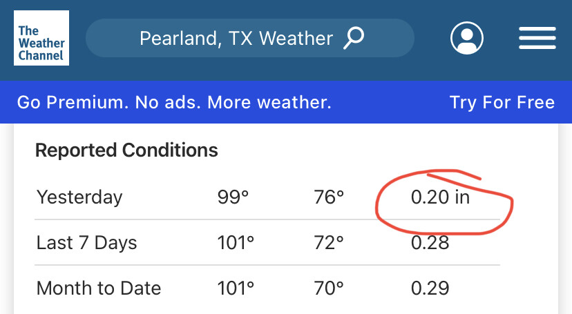
Our month-to-date is 0.09”. 
ETA: Our historic total June average is 8”.
1 Like
Ooff
If my HOA would allow it I’d zero-scape
1 Like
 The more concerning one is red now.
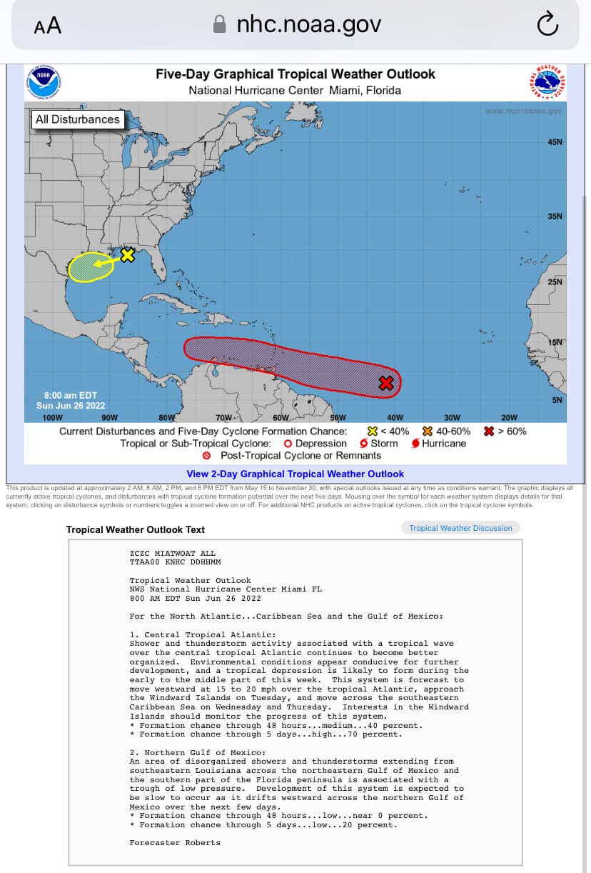

1 Like
:quality(70)/cloudfront-us-east-1.images.arcpublishing.com/tronc/FDLWC7CTPBCPHE5TP6M7MESRHQ.png)
The tropical outlook as of 8 a.m. Sunday shows two systems with potential to develop into the next tropical depression or storm. (National Hurricane Center)
The Atlantic hurricane season has a good chance of getting its second tropical depression or storm early this week from a system moving across the Atlantic while a second potential system in the Gulf of Mexico remains disorganized, according to the National Hurricane Center.
In its 8 a.m. Sunday tropical outlook, the NHC stated a tropical wave located over the central Atlantic continues to become better organized.
“Environmental conditions appear conducive for further development, and a tropical depression is likely to form during the early to the middle part of this week,” said U.S. Navy Hurricane Specialist Dave Roberts.
2 am EDT June 26: A low over the tropical Atlantic is likely to form into a tropical depression during the early to middle part of this week. The system should move west and approach the Windward Islands by Tues and be over the SE Caribbean by Wed. More at http://hurricanes.gov pic.twitter.com/oePF9NiWZB
— National Hurricane Center (@NHC_Atlantic) June 26, 2022
The wave is moving west at 15 to 20 mph, expected to approach the Windward Islands on Tuesday, and then move into the southeastern Caribbean Sea on Wednesday and Thursday, he said.
The NHC gives that system a 40% chance of forming into a tropical depression or storm in the next two days, and a 70% chance in the next five.
Meanwhile, a trough of low pressure has created an area of disorganized showers and thunderstorms from southeastern Louisiana across the northeastern Gulf of Mexico and the southern part of the Florida peninsula.
The NHC gives it a 20% chance of forming into a tropical system in the next five days as it is expected to slowly drift west across the northern Gulf of Mexico.
If either of the systems develop, they would be the season’s second system after Tropical Storm Alex, which dumped nearly a foot of rain over parts of Florida earlier this month. The next named storm would become Tropical Storm Bonnie.
M.27JUN2022
:quality(70)/cloudfront-us-east-1.images.arcpublishing.com/tronc/ZCLD4Y6UTNCDJD62V3EZBKDKAQ.png)
The National Hurricane Center identified a third disturbance; a second tropical wave in the eastern Atlantic Monday morning. (The National Hurricane Center)
On the fifth week of hurricane season, meteorologists are keeping their eyes on three disturbances with odds of becoming the second tropical storm of the season.
First, the NHC continues to monitor a tropical wave over the central Atlantic that is continuing to improve its organization, according to the 8 a.m. Monday update.
The wave is located about 950 miles east-southeast of the Windward Islands. It is moving west at 15 to 20 mph, expected to approach the islands on Tuesday and then move into the southeastern Caribbean Sea on Wednesday and Thursday. Meteorologists speculate the system to become a tropical depression or storm before it arrives on the islands.
The NHC gives the wave a 70% chance of forming into a tropical depression or storm in the next two days and a 90% chance in the next five. A NOAA Hurricane Hunter aircraft is scheduled to investigate the system Monday afternoon.
Also, tropical storm watches or warnings could be required for the Windward Islands and the northern coasts of Venezuela.
Next, a trough of low pressure has created an area of disorganized showers and thunderstorms from southeastern Louisiana across the northeastern Gulf of Mexico and the southern part of the Florida peninsula. The NHC gives it a 10% chance of forming into a tropical system in the next two days, or 20% in the next five days, as it slowly drifts west across the northern Gulf of Mexico.
Lastly, the NHC identified a tropical wave several hundred miles southwest of the Cabo Verde Islands, producing disorganized showers and thunderstorms. Atlantic conditions could become ripe enough for the system’s development into a tropical storm in the next several days. The NHC gave the wave a 20% chance of developing in the next five days.
If any of the systems develop, they would be the season’s second system after Tropical Storm Alex, which dumped nearly a foot of rain over parts of Florida earlier this month. The next named storm would become Tropical Storm Bonnie.
After Bonnie, the next two names would be Colin and Danielle.
Nothing is going to impact Florida right now
:quality(70)/cloudfront-us-east-1.images.arcpublishing.com/tronc/QLJLSDVE6ZGYLFPMJH6ZPL3F7Q.png)
Potential Tropical Cyclone Two cone of uncertainty as of 8 a.m. Tuesday, June 28, 2022. (The National Hurricane Center)
The National Hurricane Center identified a poorly defined disturbance with very likely odds of soon becoming the next tropical storm over the course of the day while it keeps its eyes on two other disturbances with odds of developing.
The National Hurricane Center’s 8 a.m. advisory Tuesday said heavy rains and tropical-storm-force winds are likely to begin late Tuesday for islands in the Southern Caribbean for what meteorologists are calling Potential Tropical Cyclone Two. The system is currently located about 330 miles east of Trinidad with maximum sustained winds of 40 mph moving west-northwest at 23 mph.
A Tropical Storm Warning is in place for Trinidad and Tobago as well as Grenada and its dependencies, and tropical-storm-force winds extend outward up to 60 miles from the system’s center. If it becomes named, it would be Tropical Storm Bonnie. The NHC gives it a 90% chance for formation in the next five days.
The @NHC_Atlantic is monitoring several tropical disturbances.
This tropical wave has a 90% of development over the next five days. pic.twitter.com/39mVBOkbzp
— CIRA (@CIRA_CSU) June 27, 2022
“On the forecast track, the system will pass near or over portions of the southern Windward Island by late Tuesday, and move over the southern Caribbean Sea or near the northern coast of Venezuela on Wednesday and Thursday,” according to the NHC. “Some strengthening is forecast during the next 48 hours. Conditions appear conducive for development, and the disturbance will likely become a tropical storm before reaching the southern Windward Islands.”
By Friday, it could become the season’s first hurricane before making landfall in Central America.
:quality(70)/cloudfront-us-east-1.images.arcpublishing.com/tronc/CUJ4YBA6MRF35OXLKG2IYZQ2QA.png)
The tropical outlook as of 8 a.m. Tuesday, June 28, 2022 shows Potential Tropical Cyclone Two as well as two other systems with a chance of becoming a tropical depression or storm. (The National Hurricane Center)
Meteorologists are also keeping their eyes on two other disturbances with odds of becoming a tropical system.
An area of disturbance has increased its showers and thunderstorms over night and over northwestern Gulf of Mexico. More development is possible but the system currently remains disorganized. The NHC gives it a 30% chance of forming into a tropical system in the next two to five days, as it slowly drifts west across the northern Gulf of Mexico and toward Texas.
Another is a tropical wave several hundred miles southwest of the Cabo Verde Islands, producing disorganized showers and thunderstorms. Atlantic conditions could become ripe enough for the system’s development into a tropical storm in the next several days. The NHC gave the wave a 20% chance of developing in the next five days.
If any of the systems develop, they would be the season’s second system after Tropical Storm Alex, which dumped nearly a foot of rain over parts of Florida earlier this month.
After Bonnie, the next two names would be Colin and Danielle.
A tropical system could be named a tropical depression without growing to tropical-storm status. It doesn’t become named until the system has sustained winds of 39 mph and isn’t named a hurricane until it has sustained winds of 74 mph.
2 Likes

I keep hearing that in my head in Darth Vader’s voice.
1 Like

1 Like
Residents of the Carolinas work up to a surprise Saturday morning: Tropical Storm Colin had formed overnight.
According the National Hurricane Center, an area of low pressure formed just offshore from Savannah, Ga., on Friday but became better organized overnight. “As a result, and rather unexpectedly, Tropical Storm Colin has formed near the South Carolina coast, centered just inland a bit to the northeast of Charleston,” the hurricane center said Saturday morning.
At 8 a.m., Tropical Storm Colin was located about 25 miles west-southwest of Myrtle Beach, S.C., with maximum sustained winds of 40 mph. Tropical-storm-force winds extended out 70 miles from Colin’s center.
Topical Storm Warnings are in effect for South Santee River, South Carolina, to Duck, North Carolina and Pamlico Sound.
“Colin is moving toward the northeast near 8 mph, and this general motion is expected to continue through Sunday. A turn toward the east-northeast with an increase in forward speed is expected late Sunday and Sunday night,” the NHC said.
:quality(70)/cloudfront-us-east-1.images.arcpublishing.com/tronc/7EJSQCHJSBCMRNOBMQIM2EMD6M.PNG)
The forecast track of Tropical Storm Colin, from the National Hurricane Center. (NOAA/National Hurricane Center)
“On the forecast track, the center of Colin is expected to move northeastward along or just inland of the South Carolina and North Carolina coasts through Sunday, and then emerge over the western Atlantic Ocean late Sunday.”
Meanwhile, Tropical Storm Bonnie continues moving across Central America and it heads from the Atlantic to the Pacific.
At 8 a.m. on Saturday, Bonnie was located about 5- miles northwest of Liberia, Costa Rica, moving west at 14 mph. It’s maximum sustained winds were 40 mph.
A Tropical Storm Warning is in effect for Limon, Costa Rica northward to Sandy Bay Sirpi, Nicaragua and from Cabo Blanco, Costa Rica northward to the border of Nicaragua and Honduras. “Interests along the Pacific coasts of El Salvador, Guatemala, and southern Mexico should monitor the progress of Bonnie,” the NHC said.
:quality(70)/cloudfront-us-east-1.images.arcpublishing.com/tronc/AMZINSQLIFBWVD4KTSIKE5MD34.PNG)
The National Hurricane Center on Saturday was monitoring two Tropical Storms and a tropical wave in the Caribbean. (NOAA/National Hurricane Center)
And forecasters are still monitoring an area of disturbed weather in the Eastern Caribbean that has a 10 percent chance of developing into a tropical depression over the next several days.
“A tropical wave continues to produce a broad area of disorganized showers and thunderstorms over the Windward Islands and eastern Caribbean Sea,” forecasters said. “Upper-level winds are not conducive for significant development as the system moves west-northwestward during the next few days across the Caribbean Sea.”
3 Likes
I was so surprised when I woke up to Colin this morning! (I mean saw it on NHCs website, I don’t live near it.) I usually say give me hurricanes over most other natural disasters just in that you know one is coming and have a couple of days to complete preparations. Not in this case!
3 Likes
This is a good point… usually hurricanes or tropical storms give plenty of lead time… they don’t just drop in unannounced
2 Likes
My second cousin in NC (who is a farmer BUT a climate change denier) had something on FB about tropical storm warning and SC please keep your spawn away…and it was everything I could do to NOT say “OK, a tropical storm pops up overnight…but climate change is a hoax?”
2 Likes
I thought about the significance of this too, it’s kinda’ scary
2 Likes
Very scary!!
I’ve lived in Spartanburg, SC during Hurricane Hugo, Raleigh, NC during Hurricane Floyd, and NYC during Super Storm Sandy and have seen the damage. Thankfully my exact area in Brooklyn is not in an evac zone, but the subways still flood if even a rainstorm is heavy enough. The thought of these things popping up with no warning and no cross-ocean trek (which we’ve been led to believe is how these things develop) is terrifying!
2 Likes