Astra Space launch today from Canaveral on mission to serve up real-time hurricane data
By Joe Mario Pedersen
Orlando Sentinel
•
Jun 12, 2022 at 7:00 am
Expand
:quality(70)/cloudfront-us-east-1.images.arcpublishing.com/tronc/NHAAWMGFYJF4PP6EVABQ6VONAQ.jpg)
An image of Cyclone Emnati taken by the TROPICS Pathfinder satellite with a 205 GHz channel on Feb 10, 2022. The image depicts an eye within an eye due to an eyewall replacement cycle. The red colors are warm air. The blues are cold air. The deep blues are from ice scattering in the tops of the rain bands. ( Massachusetts Institute of Technology’s Lincoln Laboratory.)
Starting this hurricane season scientists will be able to look at storms in a way they’ve never been able to before.
On Sunday, NASA in a partnership with Astra Space will be launching the first two of a six-part constellation of weather satellites to observe hurricanes in real time.
The two-hour launch window opens at noon for liftoff of Astra’s Rocket 3.3 from Space Launch Complex 46 at Cape Canaveral Space Force Station. Space Launch Delta 45′s weather squadron gives the chances for good weather at only 50% at noon, and worsening conditions to only 20% chance by the end of the window at 2 p.m. A 24-hour delay would see better conditions with 70% condition at the beginning of the window worsening to 50% by the end on Monday.
The bread-loaf sized cubesats, each weighing 10 pounds, are part of the Time-Resolved Observations of Precipitation structure and storm Intensity Constellation, otherwise known as the TROPICS mission, which was designed to give meteorologists a better understanding of hurricane structure and the rapid intensification process, said TROPICS principle investigator William Blackwell.
:quality(70)/cloudfront-us-east-1.images.arcpublishing.com/tronc/AAEOWACBLBFDRHKRXKZKKTKRKU.png)
The Time-Resolved Observations of Precipitation structure and storm Intensity constellation, otherwise known as the TROPICS mission, which was designed to give meteorologists a better understanding of hurricane structure and the rapid intensification process. The first pair of six cubesats launch with Astra Space this Sunday. (Massachusetts Institute of Technology’s Lincoln Laboratory)
“What makes hurricanes so difficult to observe is that they’re changing so rapidly, on time scales of minutes,” Blackwell said. “Rapid intensification has these fundamental properties of temperature, moisture and precipitation that are changing rapidly. There’s a lot of variability in space, too. You need high elevation to capture the high resolution and spiral structure from space.”
TROPICS is designed to make capturing those fundamental properties easier by resolving both the challenges of time and space that come with observing a system, with each cubesat being placed in low-Earth orbit about 340,000 miles above the Earth.
What TROPICS accomplishes in time that other weather satellites don’t is the quick rate of time the cubesats will be able to capture hurricane information. When a storm takes shape, a TROPICS cubesat will pass overhead capturing data measurements of moisture, temperature, structure and intensity, then relay that information down to Earth. An hour later, another cubesat will swing by and observe more data, giving scientists a better understanding of how hurricanes change hour by hour.
“We’re missing all the dynamic activities of the storm,” Blackwell said. “We’re hoping these (satellites) will make more rapid observations yielding better forecasts.”
Earlier this year, the National Oceanic and Atmospheric Administration, along with NASA, launched GOES-T — short for Geostationary Operational Environmental Satellite — allowing scientists to monitor and predict environmental conditions like hurricanes, thunderstorms, floods, dense fog and fire. However, GOES-T, which will be renamed GOES-18, makes measurements in visible and infrared light that can be blocked off by cloud tops. TROPICS would be taking measurements on a microwave wavelength, which would allow scientists to see what’s happing through the cloud ceiling in the storm environment, Blackwell said.
The TROPICS mission is spearhead by the Massachusetts Institute of Technology’s Lincoln Laboratory. Blackwell, who just celebrated his 20th year anniversary in the lab, oversees the TROPICS budget, which has a cap of $30.2 million and includes the creation of the cubesats as well as their operation. The Lincoln Lab enjoyed success in the TROPICS mission last year when its test satellite, Pathfinder, launched and captured images and measurements of Hurricane Ida — the costliest hurricane of the 2021 season.
Blackwell is hoping the new cubesats will begin relaying information to hurricane specialists with the NOAA, and other parties, later this year. After Sunday’s Astra Space launch deploys the first two cubesats, TROPICS will have a 120-day window to place the other four cubesats in different orbits. Two more launches are planned this year to deploy the remaining satellites.
TROPICS has been in development for the last five years and is part of a massive collaboration with the NOAA, the University of Wisconsin, MIT, Vanderbilt, NASA and the Atlantic Oceanographic and Meteorological Laboratory as well as some commercial entities.
“It’s exciting to see it all come together, getting the constellation online with high resolution rates of data available later for this hurricane season,” Blackwell said.


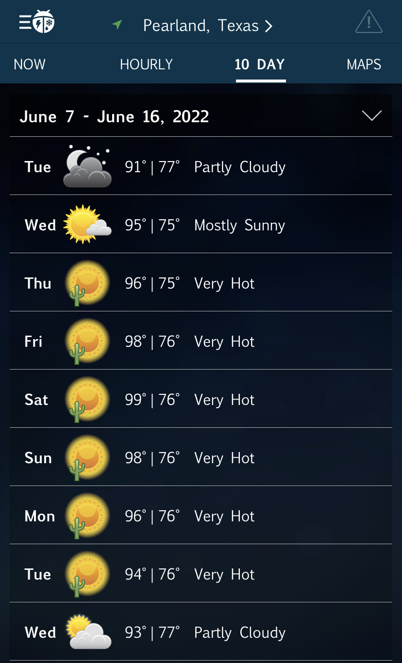

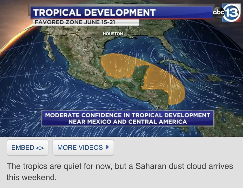


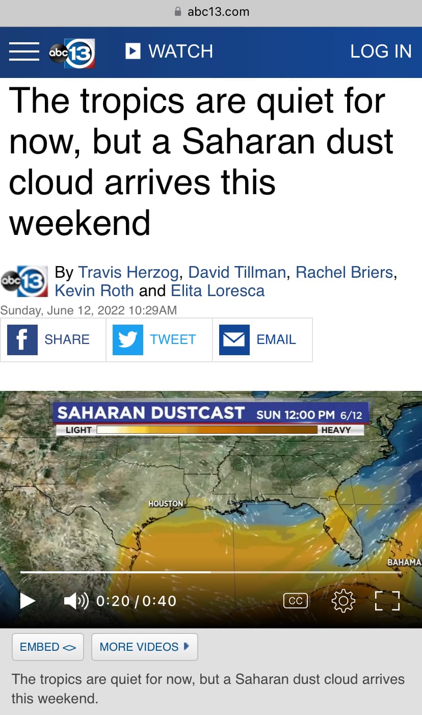


 My Bonnie lies over the ocean… My Bonnie lies over the sea… Bonnie will be the name, IF it develops
:quality(70)/cloudfront-us-east-1.images.arcpublishing.com/tronc/UWPR3DADQRA7BEGK33KR4GWJUU.jpg)
