A1.
Complete sentence.
A1.
Complete sentence.
The GEFS and the European storm models don’t agree on what form the system may take due to the drier air possibly hindering its growth, but models do agree that Florida remains in range for now. Using model data, the NHC predicts Fred could drop 5 inches of rain across the Keys and the southern Florida peninsula, with isolated maximum totals of 8 inches.

Map: Here’s the latest forecast track of Tropical Storm Fred
AUG 11, 2021 AT 8:24 AM
One track of the Hurricane Analysis and Forecast System model has the storm passing through the Everglades as a Category 2 hurricane and arriving in Fort Myers as a tropical storm, according to the NOAA projections. However, most tracks show the disturbance passing west of Florida as a tropical depression. As for Florida’s forecast, it’s still too early to say what might happen for sure, Gilson said, but it’s best to be prepared.

The Global Ensemble Forecast System’s model for the possible paths Tropical Storm Fred could take. No matter the path, the GEFS does not have Fred powering up over its tropical storm status. (The National Oceanic and Atmospheric Administration)
“Whether it’s this storm or another be prepared. We are re-entering the most active part of hurricane season,” McCann said. “The long range forecast shows there is something else behind Fred. We must be on guard and prepared.”
Meanwhile, a Tropical Storm Warning remains in place for Dominican Republic on the south coast from Punta Palenque eastward and on the north coast from the Dominican Republic/Haiti border eastward.
The Government of Cuba has issued a Tropical Storm Watch for the provinces of Ciego de Avila, Camaguey, Las Tunas, Holguin, Granma, Santiago de Cuba, and Guantanamo.
A Watch also remains in effect for Haiti from the northern border with the Dominican Republic to Gonaives, the Turks and Caicos Islands and Southeastern Bahamas.
The ECMWF (Euro) model was laughably wrong with Elsa, taking it east of the peninsula. GFS was pretty much spot on for intensity and track even a week out. Our local weather people, whom I say to no end are very good, went into great detail why this will very likely a mid-range tropical storm when it passes this area. But we will get wind and rain commensurate with Elsa, so I’ve moved my WDW trip that was going to be this weekend to 8/28-30. I’d be leaving town as the storm is getting serious here, and it’s just outright dumb to drive 150 miles through wind and rain. Plus the weekend will probably be a washout anyway,
I agree. It’s just easy to c/p from paper. Glad you were able to adjust your trip
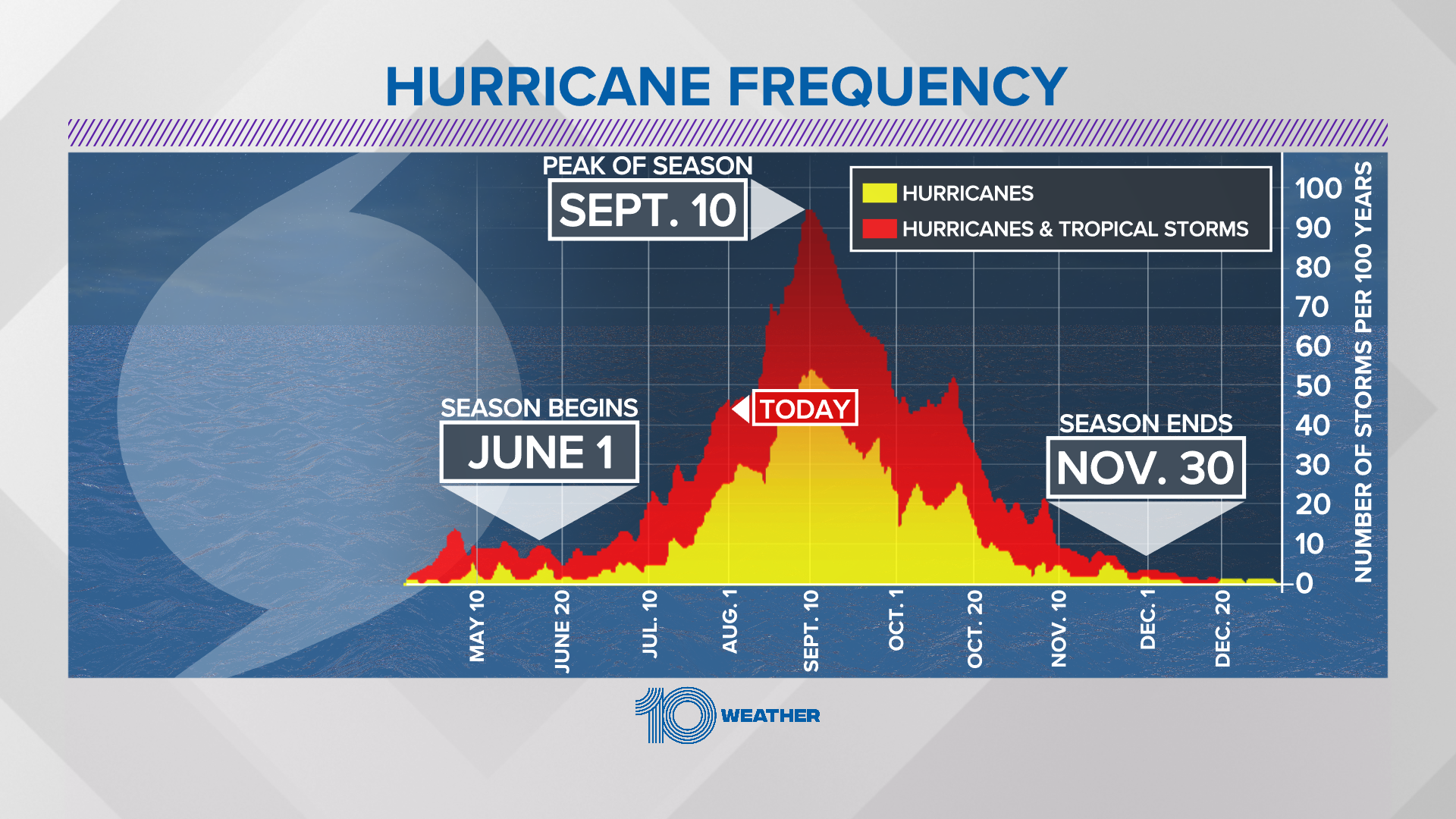
For what it’s worth, September 10th is the statistical peak of hurricane season in peninsular Florida.
So if my flight is scheduled to leave the north east at 6am on Monday, what are the chances it’ll actually leave on time or at all?
This is my third try at this trip with my son. I canceled Labor Day 2019 for a hurricane and rescheduled for June 2020 which obviously was also canceled. If this one gets canceled for another hurricane  . I do not like this cycle!!
Not what you want to hear, but it’s too early to tell. The Orlando airport didn’t close for Elsa, and the scenario for Fred is pretty similar as of now. If the airport doesn’t close, then there are no cascading delays, and your schedule would be minimally affected.
What happens over Hispaniola in the next 12 hours is going to be determinative as to what happens in the next 3-4 days.
Leaving on a 7:20 am flight from up north too. Good thing we don’t have much planed for that day.
I’ll be keeping an eye on it. Won’t be cancelling though.
*planned, not planed. I’ll be on a plane, that is my plan 
Perfect!!! I’ll be there the 15th!
Looks like Orlando area will be pretty clear. hope I didn’t jinx this
The 5 p.m. cone of uncertainty saw a continued shift west so that most of Central Florida is out of the projected path, although the effects could still be felt with most rainfall usually to the northeast of the tropical system’s center.
Meteorologists have a better image of Fred now that it’s isolated in open waters. Recon flights and satellite data have shown Fred’s circulation is not closed, said Beven.
“Based on the evidence of the closed circulation, the system will be maintained as a tropical depression for this advisory. However, the structure is currently closer to that of an open wave than a normal tropical cyclone,” Beven said.
Long-range forecasts have Fred parked off Key West on Saturday with a restored tropical storm status and 45 mph sustained winds and gusts up to 50 mph. It’s then projected to grow in the Gulf of Mexico off the Florida Coast with 60 mph sustained winds and 70 mph gusts. A potential Monday landfall is predicted in the Florida panhandle near Eastpoint.
I arrive in Orlando next Friday evening. STAY AWAY FROM ORLANDO UNTIL I GET THERE, GRACE.
Even though Fred just got here he’s an after thought and way out in the middle of the gulf. Now onto Grace:
Tropical Storm Grace cone of uncertainty as of 5 a.m. Saturday, Aug. 14, 2021. (National Hurricane Center)
Tropical Storm Grace formed Saturday morning with a long-range forecast that threatens Florida by mid-week.
The tropical wave grew into the 2021 hurricane season’s seventh named storm as of the National Hurricane Center’s 5 a.m. advisory located about 420 miles east of the Leeward Islands with maximum sustained winds of 40 mph moving west at 22 mph.
and it looks like Grace is going to take a similar path.
https://twitter.com/nws/status/1426563782122217473?s=21
The Force is with me, and I am One with the Force
Chirrut Imwe is definitely one of my top SW characters


