The city where my sister went to college had a sales lot for mobile homes. Their sign had a rotating mobile home on the top. We always alternated between thinking it was in poor taste and cracking up saying “And if you’ll look on top of the sign, that’s what your new home will look like in a tornado.”
4 Likes
Sure.
There’s nothing we can do about it anyway so we will adapt
2 Likes
We have plenty of signs and merchandise here in Ames, IA featuring the Iowa State University Cyclones (the school’s sports nickname - not mascot, who is Cy the Cardinal), but any statue of one is not that big - fortunately. This is at the Alumni Association building.

5 Likes

1 Like
That depends entirely on the surrounding air masses and conditions. There is a front over northern Florida generating westerly winds that’s drawing Gulf moisture across the peninsula, and will continue to do so until it lifts northward. That front is what will govern Elsa’s track once it’s in the Gulf. Rain chances are upwards of 60% daily through Thursday.
3 Likes

5 Likes
It seems to continue to track in the path shown, although the down grade seems to have narrowed the cone. Once over the gulf they’ll have to keep a watch since Else has slowed down from her original 30 mph to 14mph. Slowing gives the storm more time over warm gulf waters to pick up strength. It still looks like central FL (Disney) will just get a lot of rain w/ possible weather related storm events.

5 Likes
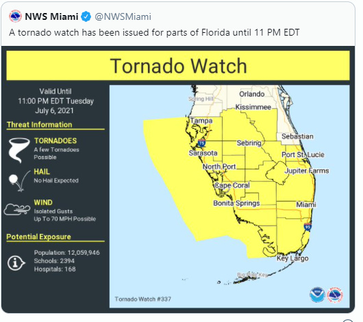
Tropical Storm Elsa is forecast to become a hurricane once again before it makes landfall Wednesday morning in the Tampa area, the National Hurricane Center said in its 2 p.m. update. Additionally, the National Weather Service issued a tornado watch extending from Tuesday afternoon and into the night for most of the peninsula.
2 Likes
Boo.
(To Elsa, not you.  )
)
2 Likes
I knew who the boo was meant for I thought Elsa would gain strength too once it got over open warm gulf waters. I’m not happy to be on the east coast and dealing w/ Elsa tantrums
2 Likes
I thought it was Boo to you (and you and you and you and you and you)!
4 Likes
There is considerable wind shear that’s causing a significant offset between the center of circulation at the surface vs at altitude and that’s really limiting the potential for strengthening. Of more concern is the change in heading to almost due north which is going to potentially make landfall in a more populated area, and the slowing of forward speed, allowing for more storm surge.
It’s been raining since 10 this morning here and winds are sustained at 20. We’re going to see 40+ winds with gusts to 60 starting around 7:00.
3 Likes
they’ve been talking about Elsa since the beginning of her running faster at the top, of the system, which prevented her from gaining more strength early on. You are in Lee Cty right? Be safe!
This is not good for the Surfside area.
This is awful.
1 Like
They did a controlled take down of the remaining structure the other day to prevent any possible storm issues. It really helped w/ their recovery efforts. Residents didn’t have a lot of time to move out though… maybe 24-48 hrs.?
1 Like