I mean it fits though, lol. Maybe not time-of-the-year wise, but drink wise… definitely!
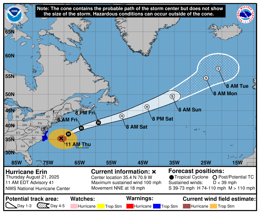
I know it looks close but those ships really do skirt close to storms all the time. On the map it looks close but it really a good distance away.
I mean it fits though, lol. Maybe not time-of-the-year wise, but drink wise… definitely!
I know it looks close but those ships really do skirt close to storms all the time. On the map it looks close but it really a good distance away.
New video of Storm Surge hitting Outer Banks NC
Seems crazy that there are homes in that position! I hope those foundations are much stronger than they appear. Looks like they’re almost designed to wash away.
They’re up on stilts so the ocean will go below them — mostly ![]()
there are literally zero homes being swallowed in that video ![]()
I’ve seen lots of videos of houses like this being washed away. Not in this video though. ![]() I hate false advertising.
I hate false advertising.
Yes me too. But in this video, the houses’ stilts are functioning as intended
Never been to the Outer Banks but I just returned last week from vacation in the Florida panhandle. Been there many times and there’s many homes on piers. The ground level is planned for flooding and surge survival with serious footings for the piers
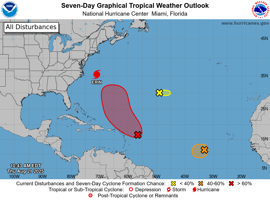
Orange 1 is now Red 1 and definitely seems like it will make that northward turn. Orange 2 is still orange.
Watching this thread due to upcoming September trips…east coast beach weekend the weekend after Labor Day (already booked) plus tentative WDW/Uni for my bday at the end of September.
I simultaneously have storm fatigue AND open this thread with each new post.
I am not sure what that says about me.
Oh I get it. ![]()
What’s this little bugger doing out there?
I’m wondering if @Shmebulock will end up having wind and rain from Erin.
My bandwidth for “unprecedented events” is completely saturated.
Probably just in time for the weekend ![]()
![]()
I’m right there with you
Red 1 is officially being called “Invest 90L” at the moment, until it turns into a tropical storm, and then it will get a name.
Big issue with this storm, though, is that Erin is, quite literally, stealing all of 90L’s thunder. It’s taking the same path as her, and she’s pretty much absorbed all of the energy in that path. The water is now cooler, it’s more agitated.
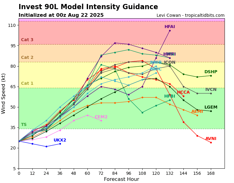
Most of the models are saying this will turn into a hurricane, but it will be a Cat 1 - 2 at most. Nothing like Erin. Now, if it gets too close to the coast, then there may be trouble, especially from many of these places getting a sideswipe from Erin.
Orange 1, officially Invest 99L, is even more precarious. It’s feeding off of leftovers of leftovers. The models don’t see much from this storm at all.
3 models see a Cat 1, 4 see a TS, the rest of it being nothing notable.
The Yellow guy is currently a big mystery.
I do not like 90L who’s likely to become Fernand.
DH managed to fly out of Bermuda this morning (just some vanilla thunderstorms and surf) but the cats are all alone and DH is the world’s most optimistic prepper (as in he doesn’t, really). I’m not even sure he closed all the storm shutters.
Oh no! ![]()