Ugh. Because of course, i booked a last minute cruise for the first week of June. 
1 Like
You’ve got time to watch, it’s too soon to know 
1 Like

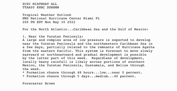
NHC is monitoring a system of disorganized showers and thunderstorms over the Gulf of Mexico that has a 10% chance of development within the next 48 hours, according to a 2 p.m. report.
“Surface pressures remain high and environmental conditions do not appear favorable for significant development before this system moves inland over the central Gulf Coast in a day or so,” NHC specialist Philippe Papin said. “Regardless of development, the system could produce heavy rainfall and gusty winds over portions of the central Gulf Coast from southeastern Louisiana to the western Florida Panhandle.”
:quality(70)/cloudfront-us-east-1.images.arcpublishing.com/tronc/OYWHJ65JRJEEJLJ4ZN54QED5T4.png)
The National Hurricane Center issued its first national tropical weather outlook on Sunday for the 2022 season. (NHC)
Hurricane season officially starts on June 1. The 2022 hurricane season is expected to be a busy one, according to the meteorological team at Colorado State University. Its forecast released in April called for an above-average year with 19 named storms this season — five more than what the National Oceanic and Atmospheric Administration considers average, based on data collected from 1991 to 2020.


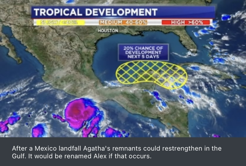

Agatha projected to become a major hurricane before landfall in Mexico. We’ll see what comes out the other side.


2 Likes


Is all of this normal? I thought Gulf activity was typically much later in the season?
1 Like
Former Pacific hurricane has 60% odds rebirthing as Atlantic season’s 1st tropical system, takes aim at Florida
By Roger Simmons, Lisa Maria Garza, Richard Tribou and Joe Mario Pedersen
Orlando Sentinel
•
May 31, 2022 at 7:47 am
Expand
:quality(70)/cloudfront-us-east-1.images.arcpublishing.com/tronc/K7KUKNEF7VFYVE5GK5DONBNPQQ.jpg)
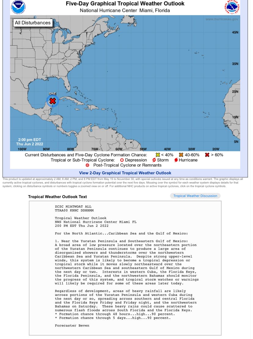
The tropical outlook for the next five days shows a 60% chance of system generation as of 2 a.m. Monday, May 31, 2022. (The National Hurricane Center)
The remnants of a Pacific category 2 hurricane that hit Mexico Monday have higher odds of reforming into the first tropical storm in the Atlantic this season while aiming for Florida by the tail-end of this week.
The National Hurricane Center said the odds of tropical development of what would be the Atlantic hurricane season’s first system over the next five days is at 60% as of its 8 a.m. tropical outlook. The NHC also said the system has a 10% of forming in the next two days.
Hurricane Agatha made landfall Monday afternoon near Puerto Angel, Mexico, with 105 mph winds. After the storm moves over land and eventually dissipates, it could reform into a system with the potential to become Tropical Storm Alex.
“Despite strong upper-level winds over the area, this system could become a tropical depression while moving northeastward over the northwestern Caribbean Sea and the southeastern Gulf of Mexico late this week,” said NHC hurricane specialist Robbie Berg.
Spectrum News 13 meteorologist Maureen McCann said Monday that it’s too early to tell what the system will develop into and where it would go, but “there are some indications that some of the moisture that is currently approaching Mexico today will lift into the Gulf and it could enhance our rain chances later in the week into next weekend.”
experts have wanted to change the date of the start of the hurricane season for a while now. Hurrican season is normally June 1 - Nov 30 but they want to have an official start moved to May 1st.
2 Likes
I’m located in Boston and follow a well-known, local meteorologist and teacher. I like him because he is very no-nonsense and is willing to say “we don’t know” in terms of what a storm (usually a snow storm up here) will shape up to be. It’s also cool to learn a lot of the science behind the weather. Anyway… he has been saying for many weeks now that this is likely to be an incredible year for hurricanes. The la nina force this year and the ocean temps, etc. are all contributing to ideal conditions. So buy your travel insurance now for those summer and fall trips!
2 Likes
Have you seen the 2020’s?!? 
Welcome to climate change.
4 Likes
Glad to know I wasn’t completely making it up ![]() It’s super early in the season for Gulf activity.
It’s super early in the season for Gulf activity.
There’s also a troubling development in the Gulf of Mexico. The Loop Current a current of warm water, has moved surprisingly far north for this time of year. The current, which flows like a river within the sea, brings warmer water from the Caribbean to typically cooler waters closer to the US Gulf Coast. That’s especially worrying news for the season since hurricanes feed off heat energy.
“It’s higher octane fuel,” says University of Miami oceanography professor Nick Shay. “It’s the 800 pound gorilla in the Gulf.”
Shay is concerned that the Loop Current’s current behavior looks similar to the 2005 Atlantic Hurricane season — when hurricanes Katrina, Rita, and Wilma ripped through Gulf Coast communities.
“In 2005, we have what is known as the hurricane Trifecta in the Gulf of Mexico,” Shay says. Both Katrina and Rita developed explosively into Category 5 storms after crossing paths with the Loop Current’s warmer waters. Hurricanes Ida in 2021 and Harvey in 2017 were also strengthened by the Loop Current
1 Like


Hoping it remains just a tropical depression because we need the rain
1 Like
Even if a tropical storm, if it sticks with that track, I think it puts Orlando on the “clean” side as it comes in? “Dirty” side as it moves onto the Atlantic, but should have lost a lot of intensity passing over land? Am I thinking correctly? So very little potential for wind damage on the north side of the path?
1 Like
Yep, you got it
1 Like
